"False"
Skip to content
printicon
Main menu hidden.
Porträttbild
Published: 2025-09-18

Subtle changes in the Arctic landscape revealed from above

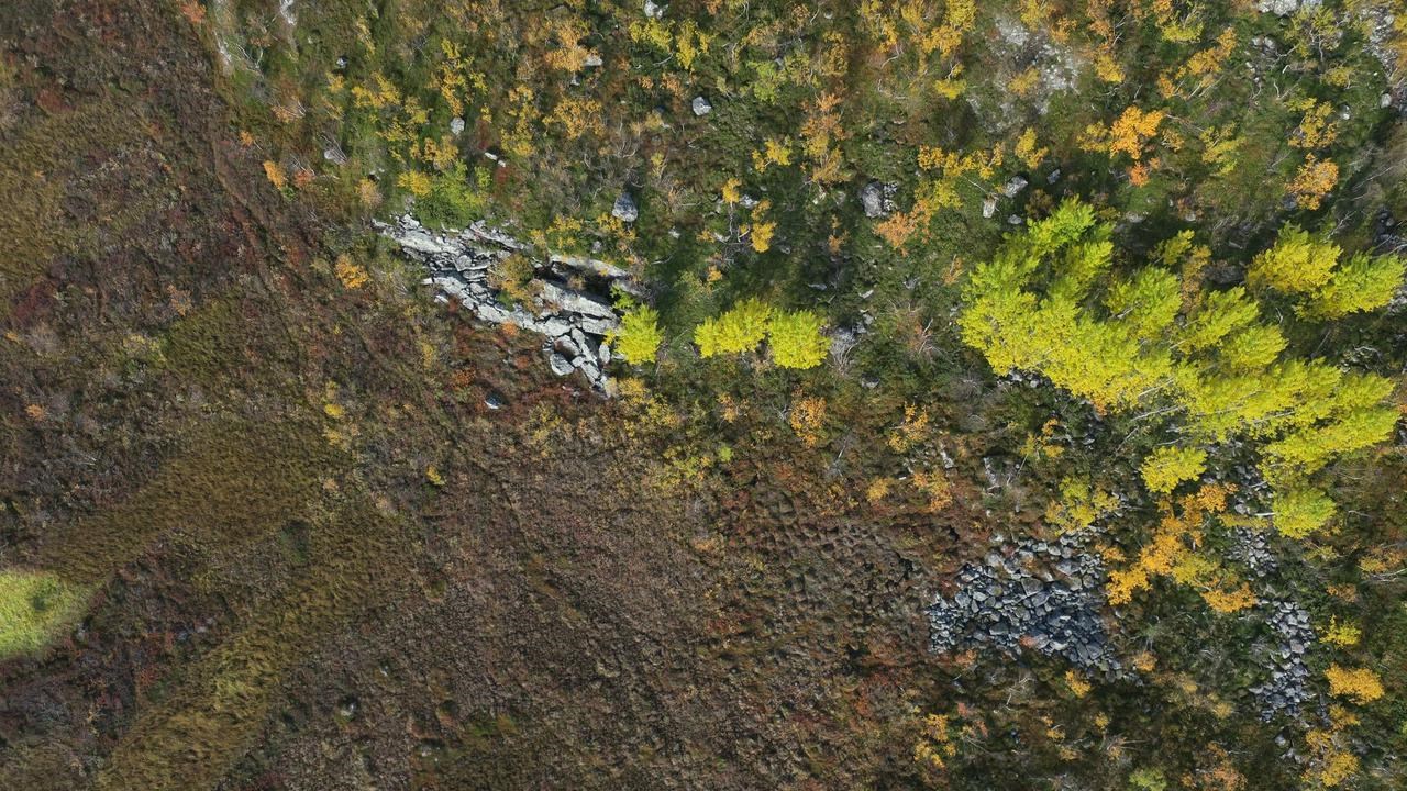
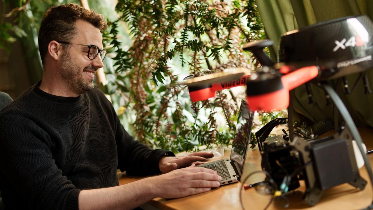
PROFILE Centimetre by centimetre, the permafrost in the Arctic is thawing while vegetation spreads. Matthias Siewert's drone images reveal how climate change is gradually redrawing the landscape, and how small changes grow big over time.

Image: Samuel Pettersson
Porträttbild

Take something as small as an ant hill or a mountain birch. On its own, it may seem insignificant – but when you zoom out, it becomes part of a bigger pattern that shows how the Arctic landscape is changing as the climate warms.

Researcher Matthias Siewert flies his drones over the same sites in Abisko year after year. The images reveal how the permafrost in peatlands and palsa mires is slowly thawing, releasing carbon that has long been locked in the soil. They also show how the vegetation is changing.

“I have six sites where I fly regularly. Four of them are tundra areas where we study how vegetation changes over time. The hypothesis is that it should become greener as it gets warmer, but there are many ecological factors involved. Among other things, I have studied vole and lemming cycles with the help of drone images,” he says.

Feels at home in open landscapes

The research requires long hours in the field, but that suits Matthias well, as he feels most at home in nature.

“I'm drawn to these open landscapes on the tundra and in other Arctic environments. I enjoy learning more about the polar regions, there's still so much I didn't know before,” says Matthias Siewert.

He was born in Germany, where family holidays as a child always went south because his parents didn't like the cold. But Matthias was curious about what lay to the north. That curiosity led him to an Erasmus exchange in Iceland and a master's thesis on Svalbard.

With a drone, we have a resolution of 2 to 10 centimetres. That allows us to really understand what is driving these changes we see in satellite images.

Today,  Matthias Siewert is an associate professor at Umeå University, and most of his fieldwork takes place in Abisko, based at the Climate Impact Research Centre. He first tried out a drone during his postdoctoral studies, and it soon proved to be a very useful tool.

Research on another scale

Much of what we know about the effects of climate change on vegetation at large scales comes from satellite images. These images typically have a resolution ranging from ten to several hundred metres and can only show broad patterns.

“With a drone, we have a resolution of 2 to 10 centimetres. That allows us to really understand what is driving these changes we see in satellite images. That’s the big advantage: being able to see what happens on the ground and link it to underlying processes.”

Even very small changes, millimetres or centimetres per year, become clear over longer periods of time. By comparing early satellite and aerial images from the 1960s with today's images, and adding details from the drone images, researchers can document how the landscape has changed.

One of Matthias' driving forces in his work is to contribute important knowledge about nature and its responses to climate change. Another is his sense of adventure. He enjoys travelling to remote places – and sometimes it gets truly exciting. Like the time he saw a bear in Canada, or met a wolf in the middle of a village. He has also been stuck in quicksand up to his chest in northern Siberia, and once saw a polar bear on Svalbard – though only from a very long distance.

“So that one is still on the list,” he laughs.

Finding ant hills with AI

But it is not always the large animals that fascinate the most. In an earlier project, Matthias studied ants. He noticed the many ant hills scattered across the landscape and became curious about how they influenced the landscape – and whether they could be detected in drone images. They could. Around the ant hills, there was noticeably more vegetation, and the ants benefit from the rising temperatures.

To identify the ant hills, Matthias and another researcher in his team used artificial intelligence, AI.

“AI is really good at automatically extracting information from images. Over the past ten years, the amount of data from satellites and drones has increased enormously, and AI will be crucial for interpreting this data,” says Matthias.

The system even outperformed him in detecting the ant hills.

“I thought that was fun. It shows that we now have a new tool that can change the way we conduct research,” he says.

Matthias Siewert enjoys sharing his knowledge. He often uses examples from his own research when teaching, and lets students work with exercises based on his images.

Recently, he was appointed Sweden's representative to the International Permafrost Association, IPA, which promotes international collaboration in research, education and information about permafrost.

Heading towards a milestone

One of his ongoing research projects is part of an EU collaboration studying how plants and animals are affected as the permafrost thaws. His group focuses on how vegetation changes due to environmental degradation. Among other things, they fly drones over sites in Canada where oil has been drilled, to search for traces of environmental pollution.

Next year marks an important milestone in his research.

“By then we will have flown drones in Abisko for ten years, so that's what I want to focus on. How the vegetation has changed and how the palsa mires have thawed. I also want to continue developing the methods we use to understand how the environment and ecosystems are changing, so we can track climate change in a more quantitative way,” says Matthias.